
BushProof Sàrl, drawing on more than 15 years’ experience of working in southern Madagascar, supported by two hydrogeologists from the Swiss Agency for Development and Cooperation (SDC), set out to work in an appropriate way on knowledge of aquifers in the regions of southern Madagascar. Together, they financed and created a mapping tool to improve knowledge of the functioning of groundwater in southern Madagascar, which was completed in 2023.
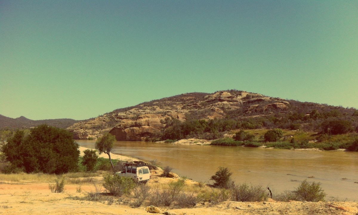
The south of the island of Madagascar has been experiencing prolonged periods of drought for several years. The growing local populations there now have very limited access to water, leading to deteriorating living conditions. However, large quantities of water flow through this area via aquifers whose functioning remains poorly understood.
Despite the presence of many players working – with limited success – on this issue and the considerable amount of water exploitation work carried out in the area over the last few decades, no accessible tool synthesizing data on groundwater flows existed until now.
On the one hand, there is a great set of detailed data freely available on the Internet, the compilation of which could greatly improve the efficiency of exploration efforts. On the other hand, BushProof Sàrl has collected a large set of data on the hydrogeology of southern Madagascar in recent years during drilling campaigns and studies it has carried out. It has generously made them available to this project so that they can be shared with as many people as possible.
The objectives of this initiative are:
- To provide technicians with useful maps for exploration.
- To improve knowledge of underground flow in southern Madagascar.
- To help improve water supply in the region by optimizing the investments made.
- To serve as a basis for future hydrogeological work.
A mapping tool accessible to all is the concrete result of this work.
A multi-stage methodology has been developed according to the following chronology:
- Collection of existing basic data or development of new products (climate, hydrology, hydrogeology).
- Updating and checking the data, linking them together and checking their consistency, enabling the creation of a reliable database.
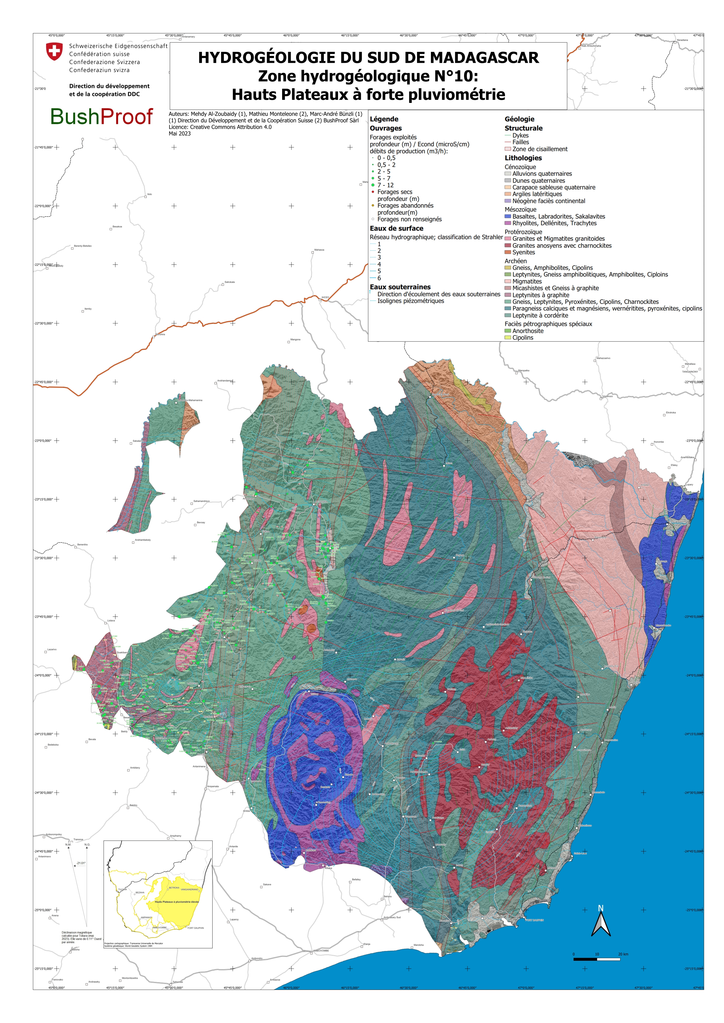
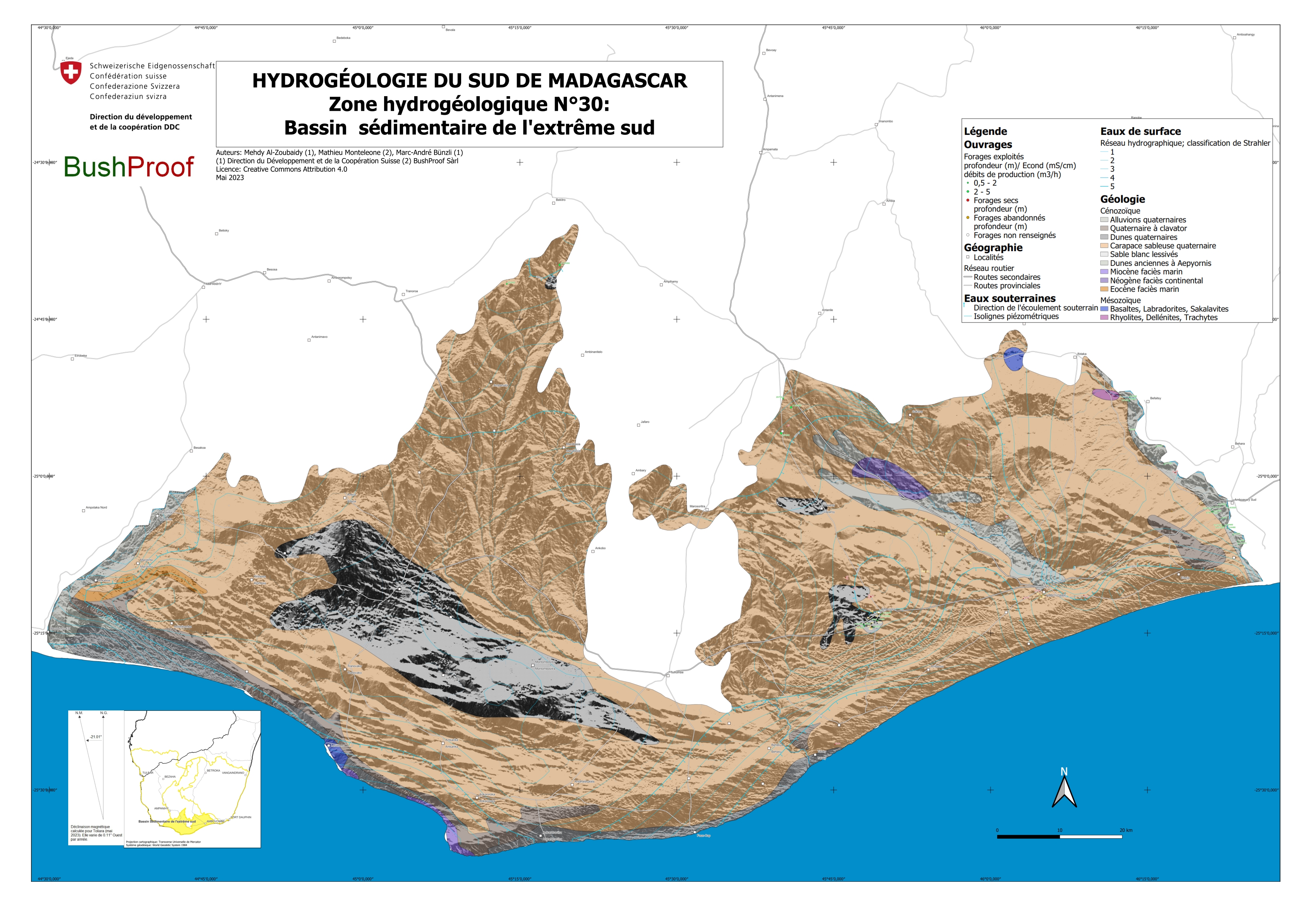
- Creation of an accessible and user-friendly mapping tool in open-source software, enabling groundwater to be mapped. A particular effort to ensure that the information is easy to read has guided the choice of cartographic representations.
- Updating our knowledge of the functioning of the aquifers in the area, considering all the data that already exists and has been worked on. This site serves to document some of this new knowledge.
All the data gathered for this work is freely accessible and must be made available to everyone. The tool took the form of an Excel database and geopackages developed with QGIS software, which can be downloaded here, enabling the data to be displayed on a map interface in which all the data is georeferenced.
This database and the geopackages will be regularly updated in the future, incorporating new relevant data and information. Future fieldwork and monitoring will help to refine the data presented.
We encourage the sharing of information, partnership, and collaboration between the various players to improve conditions for the people living in the south of Madagascar.
The published products and geopackages can be accessed via this link :
https://qgis.bushproof.com/content/Hydro%20Sud%20Madagascar/?
Terms of use and citation
All the data on this site is freely accessible and may be freely used. However, it is forbidden to sell them or to appropriate their intellectual property. These data are made available to the public thanks to the support of the Swiss Agency for Development and Cooperation, Bern, and BushProof Sàrl, Antananarivo.
We suggest using the following quote :
Al-Zoubaidy M., Monteleone M. and Bünzli, M.-A. 2023. Contribution à l’hydrogéologie du Sud de Madagascar, Base de données géoréférencées et site interactif https://hydro-madagascar.weebly.com/. Editors: Swiss Agency for Development and Cooperation, Bern and BushProof Sàrl, Antananarivo.
About the authors
The main author of this site is Mr Mehdy Al-Zoubaidy, a hydrogeologist commissioned by the Swiss Humanitarian Aid Unit to collect, check and analyze the data made available by BushProof Sàrl and that which he has produced from satellite images and public sources. He has produced most of the products on this site.
Mr Mathieu Monteleone, a hydrogeologist, is the technical director of BushProof Sàrl. He brought to the project his extensive knowledge of the hydrogeology of Madagascar, where he has carried out hundreds of boreholes. The BushProof Sàrl team was also called in to help process the existing data
Mr Marc-André Bünzli is the SDC’s thematic advisor for humanitarian WASH. He contributed to the definition of the mapping method, the GIS processing of certain data and their graphic representation.
Photo credits: BushProof Sàrl
